


Buy anything from 5,000+ international stores. One checkout price. No surprise fees. Join 2M+ shoppers on Desertcart.
Desertcart purchases this item on your behalf and handles shipping, customs, and support to SINGAPORE.
๐งญ Navigate Boldly, Never Miss a Beat
The Garmin eTrex GPS Personal Navigator is a compact, rugged handheld device featuring a 12-channel GPS receiver for precise location tracking. It offers up to 18 hours of battery life on two AA batteries, a waterproof casing, and the exclusive TracBack feature to retrace your route. Designed for outdoor enthusiasts and professionals alike, it supports up to 500 waypoints and 10 saved tracks, making it an essential tool for confident navigation in any environment.
| ASIN | B00003WGP5 |
| Are Batteries Included? | No |
| Battery Average Life | 18 Hours |
| Best Sellers Rank | 680,632 in Sports & Outdoors ( See Top 100 in Sports & Outdoors ) 112 in GPS Handhelds |
| Box Contents | Handlebar Mount |
| Brand | Garmin |
| Brand Name | Garmin |
| Compatible Devices | Smartphone, Tablet |
| Compatible with Vehicle Type | ATV, Bicycle, Boat, Car, Motorcycle |
| Connectivity Protocol | Bluetooth, ANT+ |
| Connectivity technology | Serial |
| Control Method | Touch |
| Customer Reviews | 4.0 out of 5 stars 28 Reviews |
| Display Type | LCD |
| Global Trade Identification Number | 00753759017026, 00753759026615 |
| Human Interface Types | Buttons |
| Item Dimensions L x W x H | 5.1L x 3W x 11.2H centimetres |
| Item Part Number | 0100019000 |
| Item Weight | 454 g |
| Manufacturer | Garmin |
| Manufacturer Part Number | eTrex |
| Map Coverage Type | Street |
| Model Name | Garmin eTrex Waterproof Hiking GPS |
| Model Number | 010-00190-06 |
| Model Year | 2011 |
| Model name | Garmin eTrex Waterproof Hiking GPS |
| Mounting Type | Handlebar Mount |
| Network Connectivity Technology | Serial |
| Product Features | Waterproof |
| Resolution | 480 x 272 |
| Screen Size | 2.2 Inches |
| Screen size | 2.2 Inches |
| Special feature | Waterproof |
| Sport Type | Hiking |
| Supported Satellite Navigation System | GPS |
| Touch Screen Type | Resistive |
| UPC | 753759017026 646444100106 753759026615 |
| Vehicle service type | ATV, Bicycle, Boat, Car, Motorcycle |
J**S
Lovely little unit
Very fast delivery from Amazon. The manual is clear but the unit is pretty intuitive anyway for those of us who prefer to play straight away. I almost bought a more expensive version because this is only advertised as being able to store one route. NOTE: there are 20 routes in the memory. Garmin need to update their description. I'm totally delighted with my purchase after having tested it on La Gomera during the past 2 weeks. I cannot understand why anyone would want to pay more for an "advanced" unit. This does everything I want. Battery life is pretty good considering that these things are famously greedy and this may have something to do with the fact that it just does the job in hand. Remember, the more features, the more power used. I'd think very carefully before buying a unit that uses batteries with less capacity than AA though. One necessity already mentioned by others is the lead to your computer. I agree wholeheartedly. Manual input of waymarks is no fun and if you value your thumb joint buy the lead asap.
D**W
Design fault with this eTrex H model.
I bought this Garmin-refurbished unit to replace the same model I had lost. Unfortunately it turns out that there is a design fault with this particular model. Occasionally, like once on every other trip, it switches off for no reason. It can be switched on again, but of course the tracklog up to when you've noticed is blank.
P**A
Do I recommend the Garmin eTrex? An unconditional YES.
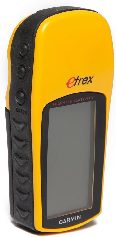
When my father bought me one of these back in 2000 as a gift I was skeptical; by then I'd heard of GPS technology but didn't reckon I had any need for it. Also I was put off from reading the instruction manual because it seemed written in a style that somehow reminded me of Homer Simpson, i.e. written with the lowest common denominator in mind, fairly low-brow, and therefore overly simple. The first Garmin eTrex I had was subjected to extreme conditions in an unexpected Force 8 gale in the English Channel. It would not be an exaggeration to say that it may have contributed in a big way to saving my life and that of my crew. I wasn't thinking of relying on it when we left harbour but - just for safety - I put in a waypoint at the harbour entrance. A few hours later we were mid-channel in my 25ft sailing boat, in pitch dark, when we were rammed by a much larger sailing vessel sailing with - apparently - no one on watch. Following this near-disaster an unexpected gale blew up and, with a damaged boat, we needed to get back to harbour - fast - in extremely challenging sailing conditions. Visibility was almost zero and we had just the reciprocal on our compass to navigate by: this is where the eTrex became invaluable. It showed the harbour entrance to be at least 40ยฐ further E of where our dead-reckoning would have suggested: we had not made sufficient allowance for tidal streams and considerable leeway in high winds; plus we had no way of calculating how far we'd drifted off course in the confused time following the collision. Since I was skipper it was my call and I chose to sail to the waypoint I'd put on the eTrex at the harbour entrance. This decision was rewarded by making a perfect landfall after a very taxing night - trying to keep the damaged boat sailing in difficult weather. We sailed into the shelter of our home harbour in the early morning light, completely exhausted but all extremely relieved. After this I was converted to GPS. I really got to grips with using the eTrex in all manner of ways and situations: one needs to be able to work effectively with it even when cold, tired, frightened and stressed. However, there is a creeping danger that we may come to rely exclusively upon GPS at the expense of being able to exercise more traditional navigational skills such as dead reckoning with the use of the log. What happens, for example, if somehow you lose the eTrex overboard, or if it simply fails for some reason? Rigorous logbook entries need to be updated at least hourly with all relevant information: in my opinion it would be complacent to rely solely on GPS; the more navigation input sources the better, I say. Unfortunately as a result of the abominable weather experienced in that gale the eTrex was exposed to huge amounts of salt water: I'd had the eTrex on a lanyard around my neck. The unit failed a little while after we reached harbour. Happily Garmin were persuaded to replace it for free. One day about a year later I looked into my kitbag and found that - somehow - during my travels, something violent must have happened and caused the eTrex screen to crack. Immediately I went to a shop and bought an identical replacement: this one I've had for several years now. Just a few days ago I bought another eTrex (this is now my 4th Garmin eTrex!) from Amazon as a back-up unit since I'm planning a sailing trip from Finland to the UK in the summer and consider a spare GPS unit as vital (just in case!). In summer 2007 I was sailing alone in the rock-strewn Finnish Archipelago when a terrific rain squall broke out and visibility was reduced to a few meters. The eTrex proved invaluable at showing me my position - by means of instant GPS fix - relative to where the rocks were shown on the chart. In this part of the world there are magnetic anomalies in the geology and in some areas compass readings can be totally unreliable, with errors of around 30ยฐ - leading to the real possibility of sailing the boat up onto a reef or shoal. I was caught like this once: I noticed breaking waves several hundreds of meters ahead indicating rocks where there shouldn't have been any. Only later I realised that I'd failed to read the notice on the chart explaining the possibility of magnetic anomalies affecting compass readings: if it had happened at night the crash as I hit the rocks would have been dramatic. Having GPS is a huge asset and serves to keep one's nerves and pulse rate soothed. The Garmin eTrex has proved valuable when calibrating the Raytheon log in my boat: it gives reasonably accurate and reliable distance readings for calibration purposes. I have successfully used the eTrex while flying to determine air speed. And I have used eTrex while driving my car and found that the speedo reads slightly less than the actual car speed according to GPS: this is good to know with respect to traffic speed cameras. I have not had any problems with battery power. I turn the eTrex on for only relatively short bursts of a few minutes just to take readings. In this way one set of batteries can easily last a whole summer. I have looked at the more expensive models but - at this stage of development (2008) - I really do not see any great advantage of spending more money. As someone has pointed out here WAAS only works in N and S America: so why pay for software that one can't use outside of N & S America? I haven't tried using PC cable. Loading waypoints manually has not been a big problem. Do I recommend the Garmin eTrex? An unconditional YES! For the relatively small cash layout you buy yourself a hugely valuable - & in my case vital - piece of safety kit.
D**L
Pretty pleased, especially for price!
I tentatively bought this as a backup for map navigation while planning an eighty mile walk. My experience on this and a second 40 mile walk has generally been very good. The battery life, even using rechargable NiMH batteries was more than sufficent for a long days walking, though carry backups! I used GPSU as recommended below to put in data and found this good and easy to use. My only problem was with losing signal while amongst high buildings, in deeper valleys and amongst trees. This was due mainly to initially misunderstanding WAAS, which I thought was only useful in America. It turns out there is a European equivilent that it uses in the UK. Turning this on uses more battery (though a set still lasts a day) but both stops the unit losing the signal and increases the accuracy of the location. For the sixty pounds I paid I think it is a very good buy - though I agree with comments below about the cost of the serial cable, expecially as I had to buy a second cable to convert it to USB.....
S**E
Very disappointing - but see update
I can't agree with the other reviews - I think this GPS is very disappointing.The problem is it's ability to receive signals, the slightest obstruction and it loses signal. I've not found this with other GPS's which I've borrowed. It's great on the top of a hill, but elsewhere it's frankly useless. It may be that mine is faulty, I am going to return it to find out.UPDATE - Following advice from Garmin, now get on much better with it - if it's strapped to the outside of a rucksack, it's far more reliable. It's a ashame th manual isn't clearer on this though!
M**N
Very good for hot air ballooning - really!
I use the eTrex for hot air ballooning. I'm a pilot and I need to know my height, speed and direction when I'm flying. The eTrex gives me that plus a variometer - a device that measures how fast one is ascending or descending). The variometer is pretty crude - because it works on GPS and not air pressure - but it's good enough as a back up if my real vario is not working (or left in the car...). Best of all, when you land and you are not quite sure where you are (this never happens to me of course), it can give you your position as Ordnance Survey map coordinates. You can then phone these to your retrieve to come and get you. The battery life is good. I run it on rechargables and it lasts several hours which is enough for a weekend's flying. The only gripe I have is that it sometimes takes ages to find satellites and sometimes loses the signal. But for the money it's great.
R**N
Very pleased
I have bought an e-trex from Amazon (excellent service). I have now used it several times in Suffolk and the Lake District. I have found it excellent, easy and reliable to use. I haven't used it with a computer nor have I used the route facility. What I wanted it for was to give a reliable location (ie grid reference) when I get lost! It does this! Other features such as elevation, total distance covered etc useful too. It does need a carry case of some sort since it can lose contact with the satelites if put in a rucksac or even a pocket. Excellent gadget.
B**M
Real Value For Money
Having recently bought the Etrex thro' Amazon, and having now used it over two 10 mile hikes, I cannot fault it especially at the price. It really does have all the essential features one needs. The instruction booklet that comes with it is well written and informative. It took less than an hour to master most of the functions. From a hill-walkers point of view there is no need to buy the more expensive models. My one complaint is with Garmin. To charge ยฃ25 for the PC lead is a rip-off, and was the only reason for not giving the model a 5 star rating
Trustpilot
1 month ago
2 months ago