We remain fully operational. Our teams are working around the clock to ensure your deliveries continue safely.

下载应用程序


Buy anything from 5,000+ international stores. One checkout price. No surprise fees. Join 2M+ shoppers on Desertcart.
Desertcart purchases this item on your behalf and handles shipping, customs, and support to SINGAPORE.
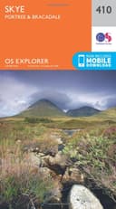
Skye Map | Portree & Bracadale | Ordnance Survey | OS Explorer Map 410 | Scotland | Walks | Hiking | Maps | Adventure : Ordnance Survey: desertcart.co.uk: Books Review: OS EXPLORER - Skye: Portree and Bracadale - Invaluable map for a serious yomp. Great detail, clear printing and compact format. Wouldn't want to venture on the hills with just a road map! Review: The detail is brilliant for walkers and many other outside pursuits - Same response I'll give on all these OS maps. The detail is brilliant for walkers and many other outside pursuits.


| Best Sellers Rank | 141,723 in Books ( See Top 100 in Books ) 1,026 in Walking (Books) 1,129 in Hiking (Books) 1,579 in Travel Atlases & Maps |
| Customer reviews | 4.7 4.7 out of 5 stars (73) |
| Dimensions | 13.4 x 1.3 x 23.3 cm |
| Edition | September 2015 ed |
| ISBN-10 | 0319246450 |
| ISBN-13 | 978-0319246450 |
| Item weight | 130 g |
| Language | English |
| Print length | 1 pages |
| Publication date | 16 Sept. 2015 |
| Publisher | Ordnance Survey |
M**N
OS EXPLORER - Skye: Portree and Bracadale
Invaluable map for a serious yomp. Great detail, clear printing and compact format. Wouldn't want to venture on the hills with just a road map!
C**M
The detail is brilliant for walkers and many other outside pursuits
Same response I'll give on all these OS maps. The detail is brilliant for walkers and many other outside pursuits.
M**G
Five Stars
Exceptional map for walking and touring off the beaten track
A**C
only the best.
OS maps,... only the best.
R**N
Five Stars
good
M**C
Four Stars
now we are ready to walk the skye trail
H**E
This Ordnance Survey Explorer Map captures the middle segment of the Isle of Skye. This includes Glen Drynoch, where a road links the east and west coasts of Skye. The map covers the area around the town of Portree, the small village of Sconser and its ferry link to Raasay, and the rugged interior of the island on the way to Loch Caroy on the west coast. The scale is a user-friendly 1:25,000. The color map graphics are easy to read. The map includes a download for your mobile. The map has a plastic cover, but the map itself is paper. Well recommended to the enterprising traveler.
S**E
Die Karte ist wirklich gut wenn man dort wandern geht. Allerdings ist wohl so ziemlich alles als Pfad gekennzeichnet, was irgendwann schon mal gelaufen wurde. Einige der Wege waren als solche kaum noch zu erkennen. Hilfreich ist natürlich auch das man grob vorab schätzen kann, wie der Boden so ist und ob man über Brücken kommt oder die Bäche etwas größer sind. Nervig für mich ist allerdings das britische Koordinatensystem. Aber das muss wohl so sein - ist ja schließlich eine britische Karte. Also wenn man das GPS benutzt vorher unbedingt das Koordinatensystem umstellen.
2**M
carte pliée à couverture cartonnée souple ancienne (2007) n°410 de la série "Explorer" consacrée à la région centrale de l'île de Skye; la carte imprimée recto seulement couvre une zone de 120x80cm soit 30 km est-ouest x 20 km nord-sud (600km2 en tout) allant du sommet Ben Horneval au nord-ouest à Sconser au sud-est et de Talisker au sud-ouest au Loch Fada au nord-est; centrée sur une région naturelle, elle ne décrit aucune agglomération d'importance (seules les bourgs de Portree, Bracadale et Drynoch); par ailleurs, pour le randonneur, les sentiers de randonnée et tous les reliefs marquants y sont figurés; l'échelle au 1/25 000ème (2.5 inch /1 mile) atteint la qualité du concurrent continental IGN Top 25 pour cette série Explorer les courbes de niveau sont bien présentes et la colorisation claire et lisible; le papier solide mais pas spécialement résistant en utilisation sous la pluie (nécessité d'une protection plastifiée) de nombreux exemplaires sont accessibles à bas prix en occasion; privilégiez les vendeurs bien notés qui vous enverront un exemplaire usagé mais en très bon état comme c'était le cas cette fois-ci satisfait de ce commentaire? répondez à la question ci-dessous
TrustPilot
3 周前
2 周前